.png)
 2 hours ago
7
2 hours ago
7
Article content

THIS CONTENT IS RESERVED FOR SUBSCRIBERS ONLY
Subscribe now to read the latest news in your city and across Canada.
- Unlimited digital access to the Ottawa Citizen.
- Analysis on all things Ottawa by Bruce Deachman,David Pugliese, and others, award-winning newsletters and virtual events.
- Opportunity to engage with our commenting community.
- Ottawa Citizen ePaper.
- Ottawa Citizen App.
SUBSCRIBE TO UNLOCK MORE ARTICLES
Subscribe now to read the latest news in your city and across Canada.
- Exclusive articles from David Pugliese, Andrew Duffy, Bruce Deachman and others. Plus, food reviews and event listings in the weekly newsletter, Ottawa, Out of Office.
- Unlimited online access to Ottawa Citizen and 15 news sites with one account.
- Ottawa Citizen ePaper, an electronic replica of the print edition to view on any device, share and comment on.
- Daily puzzles, including the New York Times Crossword.
- Support local journalism.
REGISTER / SIGN IN TO UNLOCK MORE ARTICLES
Create an account or sign in to continue with your reading experience.
- Access articles from across Canada with one account.
- Share your thoughts and join the conversation in the comments.
- Enjoy additional articles per month.
- Get email updates from your favourite authors.
Register to unlock this article — it’s free
Create an account or sign in to continue with your reading experience.
- Access articles from across Canada with one account
- Share your thoughts and join the conversation in the comments
- Enjoy additional articles per month
- Get email updates from your favourite authors
Sign In or Create an Account
or
Article content
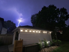
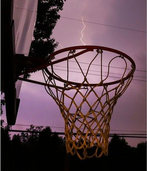
Mother Nature’s (somewhat) impromptu lightning show was the topic of the day on July 15 for some Ottawa-Gatineau and Algonquin area residents who captured and shared the colourful flashes on social media.
Article content
Article content
While the bulk of the lightning strikes happened closer to 10 p.m., Environment Canada meteorologist Kate Leclerc says the thunderstorms lasted for hours.
Article content
Article content
Between 10 p.m. and 2 a.m., Ottawa witnessed widespread strikes. As entertaining as they may have been for some, the flashes were intense, consecutive and fierce.
Article content
By signing up you consent to receive the above newsletter from Postmedia Network Inc.
Article content
So, what’s really behind the lightning strikes?
Article content
On Tuesday, Environment and Climate Change Canada had issued an expansive “yellow warning” alert for heat and a severe thunderstorm in Ottawa. Maximum temperatures were expected to reach up to 36 C.
Article content
Tuesday wasn’t as hot as what the weather agency had predicted, but it was certainly hot enough. Temperatures hovered just above 30 C, with humidity making Tuesday feel like 42.
Article content
The drastic drop in temperature (from day to night) created “leftover energy”, which resulted in Ottawa’s prolonged overnight lightning strikes, according Connor Mockett, a storm chaser and photographer based out of Winchester, about 40 minutes south of Ottawa.
Article content
“Once night came and the temperature dropped from a really hot day, storms were able to form,” Mockett said.
Article content
Article content
The explanation was simple.
Article content
Mockett pointed to the Convective Available Potential Energy (also known as CAPE). It’s a meteorological measure of the atmosphere’s instability and the amount of energy that’s available to fuel developing thunderstorms.
Article content
Article content
When there’s a lot of that CAPE energy in the atmosphere, that often means you’re going to have a lot of lightning.
Article content
Article content
“Yesterday there was about 3,000 to 4,000 CAPE in Eastern Ontario,” he says, “which is really high for here.”
Article content
Recent smoke may have lessened impact of lightning
Article content
Earlier in the week, on Sunday, the national weather agency had issued another yellow warning as smoke from Northern Quebec forest fires made their way to Ottawa.
Article content
This decreased air quality, and no one in Ottawa was really thrilled about it.
Article content
While there are fires currently in Northern Quebec, it’s actually the fires in the Western Ontario region that are feeding the smoke over Southern Ontario, according to Leclerc.
Article content
Regardless, she says the smoke definitely impacted the severity of Tuesday’s thunderstorms.
Article content
That’s because the thick layer of smoke in the air worked to inhibit the sunlight and moisture from reaching and feeding into the thunderstorm and lightning.
Article content
The science behind it may at times be hard to predict, but Leclerc says the thickness of the air due to smoke is known to impact the frequency of lightning.


























/https%3A%2F%2Fsportsmole-media-prod.s3.gra.io.cloud.ovh.net%2Fuploads%2F2026%2F07%2Fdaniel-mcgregor-huyer-zuma-press-wire-luciano-gonzalez-anadolu-abacapress-com-estadio-azteca-harry-kane-jude-bellingham-composite-6a49eb8857b70695441164.png)
 Bengali (BD) ·
  English (US) ·