.png)
 4 days ago
11
4 days ago
11
Weather experts are also betting on a snowier winter this year compared to last year
Published Oct 17, 2024 • 2 minute read

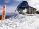
Some North Shore ski hills have received their first taste of winter.
Cypress Mountain Resort reported receiving its first snow on Wednesday followed by more snow on Thursday.
The resort’s snow cam showed the white stuff on the Sky Chair, its highest lift, at an elevation of about 1,400 metres. It also showed snow accumulating on the lower Lions Express lift going up Mt. Strachan.

On Mount Seymour, a dusting of snow is visible from the snow cam on Mystery Peak, about 1,230 metres up, while there doesn’t seem to be any snow fall on Grouse Mountain.
Snow appears to be sticking at about 1,200 to 1,300 metres depending on the area, said Environment Canada meteorologist Trevor Smith.
“October sounds about right for seeing the first snow on the North Shore mountains,” he said. “But typically it doesn’t last because the systems that can come in this time of year can get a bit warmer.”
Environment Canada has issued a special weather statement for heavy rainfall starting Friday afternoon into Sunday.
Some of that precipitation could initially fall Friday morning as snow on higher elevations on the North Shore, said Smith.
Advertisement 2
![]()
THIS CONTENT IS RESERVED FOR SUBSCRIBERS ONLY
Subscribe now to read the latest news in your city and across Canada.
- Unlimited online access to articles from across Canada with one account.
- Get exclusive access to the Vancouver Sun ePaper, an electronic replica of the print edition that you can share, download and comment on.
- Enjoy insights and behind-the-scenes analysis from our award-winning journalists.
- Support local journalists and the next generation of journalists.
- Daily puzzles including the New York Times Crossword.
SUBSCRIBE TO UNLOCK MORE ARTICLES
Subscribe now to read the latest news in your city and across Canada.
- Unlimited online access to articles from across Canada with one account.
- Get exclusive access to the Vancouver Sun ePaper, an electronic replica of the print edition that you can share, download and comment on.
- Enjoy insights and behind-the-scenes analysis from our award-winning journalists.
- Support local journalists and the next generation of journalists.
- Daily puzzles including the New York Times Crossword.
REGISTER / SIGN IN TO UNLOCK MORE ARTICLES
Create an account or sign in to continue with your reading experience.
- Access articles from across Canada with one account.
- Share your thoughts and join the conversation in the comments.
- Enjoy additional articles per month.
- Get email updates from your favourite authors.
THIS ARTICLE IS FREE TO READ REGISTER TO UNLOCK.
Create an account or sign in to continue with your reading experience.
- Access articles from across Canada with one account
- Share your thoughts and join the conversation in the comments
- Enjoy additional articles per month
- Get email updates from your favourite authors
Sign In or Create an Account
or
Article content
But freezing levels are expected to soar up to 2,500 metres starting Friday afternoon, which means any snow that fell earlier will get washed away by heavy rains.
The atmospheric river is expected to bring prolonged rainfall over Metro Vancouver, Fraser Valley, Howe Sound, Whistler, Sunshine Coast and parts of Vancouver Island.
Rainfall could reach up to 70 mm and up to 100 mm along the coastal mountains, said the weather statement. Smith said the North Shore mountains could see up to 150 mm of rain between Friday and Sunday.
After a disappointing season last year due to lack of snow, the long-term forecast presents a glimmer of hope for skiers and snowboarders this season.
Environment Canada is predicting a La Nina later this year, which favours a colder-than-normal winter for the B.C. South Coast.
Smith said a moderate La Nina like the one forecast on the heels of a strong El Nino which we had last winter “typically stacks the deck towards a snowier winter.”
“There’s a better chance of seeing snow on the North Shore mountains this year, but no guarantees,” he said.
Recommended from Editorial
-

Another big rainstorm headed for Metro Vancouver area this weekend
-

Closed for the season? Why B.C. ski hills face an uncertain future
-

B.C. weather: Heading to the pumpkin patch this October? Here's what to expect


Article content


 Bengali (BD) ·
  English (US) ·