.png)
 1 week ago
13
1 week ago
13
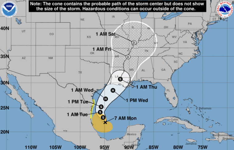
A disturbance in the Gulf of Mexico is forecast to strengthen into a tropical storm Monday, and could become a hurricane before it reaches the U.S. Gulf Coast by midweek.
The storm, called Potential Tropical Cyclone Six, is located about 300 miles south, southeast of the mouth of the Rio Grande and is moving north-northwest. It’s forecast to move offshore of the northern Gulf of Mexico through Tuesday, and approach the Louisiana and Upper Texas coastline on Wednesday, the National Hurricane Center said an early Monday advisory.
Tropical Storm Watches are in effect for northeastern Mexico as well as southern Texas.
Potential Tropical Cyclone Six is expected to dump heavy rain and trigger flash flooding along the coast of Northeast Mexico, southern Texas, southern Louisiana and southern Mississippi into Thursday morning, the NHC said.
 A trajectory map for the tropical disturbance in the Gulf of Mexico. NOAA
While it’s too soon to forecast the exact location of impacts, the storm's potential for life-threatening storm surge and damaging winds “are increasing for portions of the Louisiana and Upper Texas coastlines beginning Tuesday night,” the weather service said.
Thus far this 2024 Atlantic storm season, which starts in June and ends Nov. 30, there have been five named storms, three of which became hurricanes.
August’s tropical cyclone activity “was a little below normal” in terms of the number of named storms, the NHC said. Debby made landfall in the Big Bend region of Florida as a Category 1 hurricane before moving offshore and making landfall again as a tropical storm in South Carolina in early August, while Ernesto became a Category 1 hurricane when it moved over Bermuda in mid August.
The National Oceanic and Atmospheric Administration had predicted above-normal hurricane activity in the Atlantic basin this year, forecasting a range of 17 to 25 total named storms — which is defined by having winds of 39 mph or higher, with eight to 13 forecast to become hurricanes. The above-normal activity was forecast due to near-record warm ocean temperatures in the Atlantic, La Niña conditions in the Pacific, reduced Atlantic trade winds and less wind shear.
The next storm will be named Francine.


 Bengali (BD) ·
  English (US) ·