.png)
 6 hours ago
6
6 hours ago
6
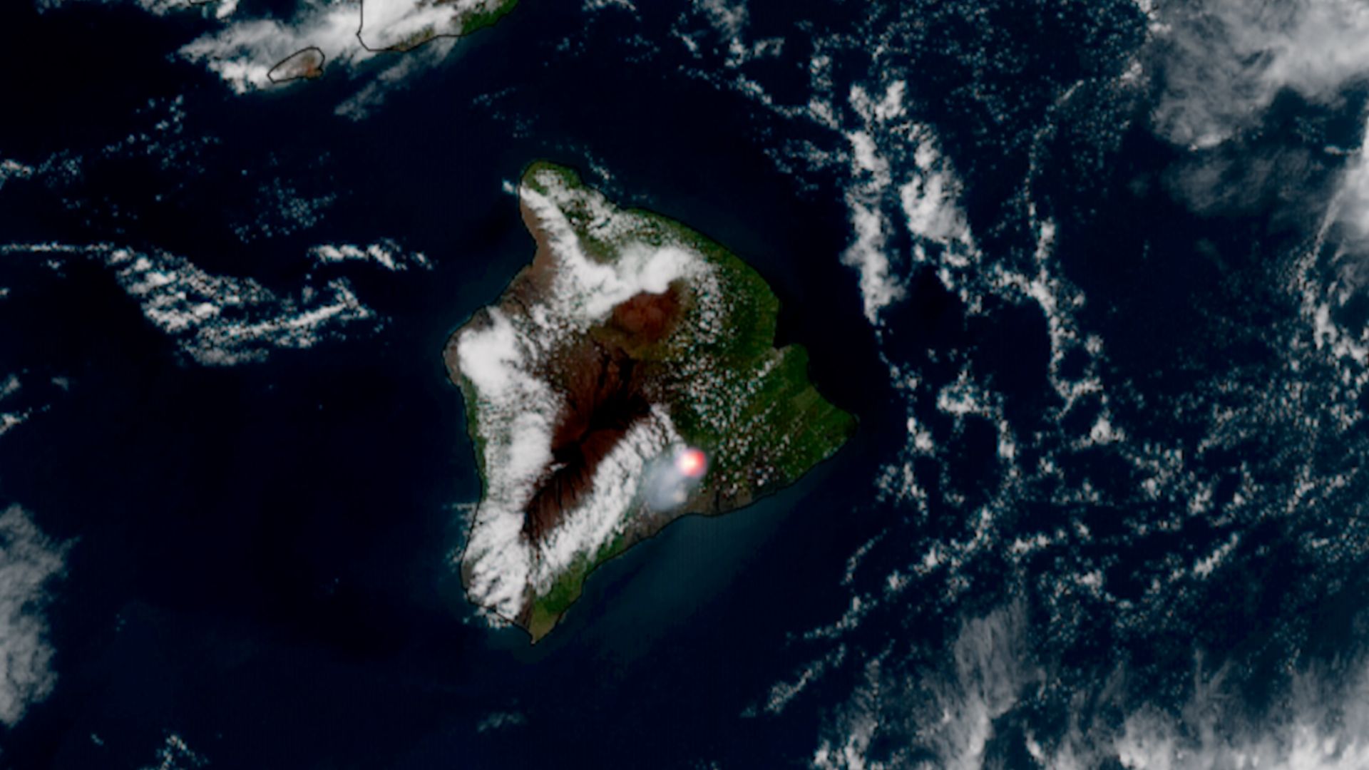
On Sunday (June 14), the Hawaiian volcano Kīlauea erupted for the 49th time that we know of — marking its 49th "episode," as scientists say.
And during the show, the GOES-18 weather satellite caught the action: the volcano blasting lava about 700 feet (210 meters) into the air. A gif of the footage can be seen just below.
Yesterday, Hawai'i's Kīlauea had its 49th eruptive episode, with lava fountains reaching about 700 feet (210 meters) into the air. pic.twitter.com/EW81mKPTNPJune 15, 2026
What are we looking at?
Specifically, in this GOES-18 satellite imagery of the Kīlauea eruption, take note of the bright red spot toward the bottom right of the island. That color indicates warm to hot fire, per the scale visible at the bottom of the gif.
The gif itself is also sped up, showcasing a timespan from 3:01 p.m. EDT (1901 UTC) on Sunday to 10:31 p.m. EDT the same day (0331 UTC the following day).
Why is it noteworthy?
It's a treat to witness Hawaii's Kīlauea volcano erupting for many reasons, one being its grandeur. It's considered the most active volcano on Earth, having consistently erupted for the last 200 years or so.
It's also huge, with a 4,090-foot (1,250-meter) summit that has a depression about 3 miles (5 kilometers) long and 2 miles (3.2 km) wide. This very large depression is what's known as a "caldera." You can think of it as a huge crater on the volcano's summit.
That crater is called Halema'uma'u, and is in fact where the eruptions of this volcano originate. This particular eruption lasted about seven and a half hours, according to the U.S. Geological Survey's Hawaiian Volcano Observatory, but no lava was reported exiting the caldera territory. In conjunction with the eruption, however, the USGS reported three earthquakes within Kīlauea caldera.
Kīlauea eruption episode 49 summary 🌋 Episode 49 lava fountaining began after approximately 5 hours of precursory lava overflows from the north vent that started at 4:10 a.m. HST on the morning of June 14. Several subsequent overflows from the north and south vents followed.… pic.twitter.com/NlKDUmJtoYJune 15, 2026
Another reason this GOES-18 satellite is pretty amazing is it illustrates once again how a weather satellite's data can be very versatile. Satellite imagery of natural disasters in particular can help scientists monitor the status of hazardous areas in order to aid relief efforts, if needed.
That's going to be especially important as human-driven climate change, caused by practices like burning coal for cheap power, continues to grow in severity. Global warming is directly correlated with increases in serious disasters like hurricanes, cyclones and wildfires. The more satellite eyes we have on these events, the better.
There are other benefits to satellite images as well — things like penguin safety and solar eclipse views, for example. And some satellites are even able to watch over humanmade disasters, such as this one that caught Blue Origin's rocket explosion from space.
As for this erupting volcano, now that it's quieted down, scientists have been trying to predict when the next outflow could occur. According to the USGS, the 50th episode is forecast to occur "between June 24 and June 29 with June 25-26 most likely."


/https%3A%2F%2Fsportsmole-media-prod.s3.gra.io.cloud.ovh.net%2Fuploads%2F2026%2F06%2Frio-ngumoha-email-sportmole-6a27b73e9a471352625861.png)
 Bengali (BD) ·
  English (US) ·