.png)
 1 hour ago
8
1 hour ago
8
Article content
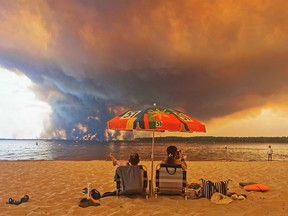
A wildfire near Bordeaux burned hot enough to make its own thunderstorm this week, and the lightning it threw started new fires. It was the first pyrocumulonimbus cloud ever recorded in France, but Canada has seen hundreds of them in the last decade.

THIS CONTENT IS RESERVED FOR SUBSCRIBERS
Enjoy the latest local, national and international news.
- Exclusive articles by Conrad Black, Barbara Kay and others. Plus, special edition NP Platformed and First Reading newsletters and virtual events.
- Unlimited online access to National Post.
- National Post ePaper, an electronic replica of the print edition to view on any device, share and comment on.
- Daily puzzles including the New York Times Crossword.
- Support local journalism.
SUBSCRIBE FOR MORE ARTICLES
Enjoy the latest local, national and international news.
- Exclusive articles by Conrad Black, Barbara Kay and others. Plus, special edition NP Platformed and First Reading newsletters and virtual events.
- Unlimited online access to National Post.
- National Post ePaper, an electronic replica of the print edition to view on any device, share and comment on.
- Daily puzzles including the New York Times Crossword.
- Support local journalism.
REGISTER / SIGN IN TO UNLOCK MORE ARTICLES
Create an account or sign in to continue with your reading experience.
- Access articles from across Canada with one account.
- Share your thoughts and join the conversation in the comments.
- Enjoy additional articles per month.
- Get email updates from your favourite authors.
THIS ARTICLE IS FREE TO READ REGISTER TO UNLOCK.
Create an account or sign in to continue with your reading experience.
- Access articles from across Canada with one account
- Share your thoughts and join the conversation in the comments
- Enjoy additional articles per month
- Get email updates from your favourite authors
Sign In or Create an Account
or
Article content
Pyrocumulonimbus clouds, the fire-generated thunderstorms contributing to the blazes that forced tens of thousands of people from the region in southwest France this week, are rare in Europe. NASA has called them the “fire-breathing dragon of clouds.”
Article content
Article content
Article content
The Gironde prefecture said Thursday that the fire has burned 42,000 hectares near Saumos, southwest of Bordeaux, and has held at that size since Tuesday. About 3,300 firefighters, 1,500 military personnel and 24 aircraft are assigned to it.
Article content
By signing up you consent to receive the above newsletter from Postmedia Network Inc.
Article content
Sophie Brocas, the prefect of Gironde, authorized residents of nine more municipalities to return home Thursday. That brought to 144,000 the number cleared to go back, and the A63 motorway reopened in both directions at 2 p.m., her office said. The prefecture said 231 firefighters have been injured and 240 homes destroyed, and that smoke has left the Nouvelle-Aquitaine region under an episode of degraded air quality. Smaller fires continue to burn in southern France, including one in Brignoles that has forced actor George Clooney and his family to evacuate their estate.
Article content
The fire clouds form when a wildfire burns hot enough to punch a column of air into an unstable atmosphere, and they behave like thunderstorms because that is what they are.
Article content
“So a pyrocumulonimbus cloud is a thunderstorm cloud that forms over an active, and usually a very active, wildfire,” said Peter Kimbell, a warning preparedness meteorologist with Environment and Climate Change Canada.
Article content
Article content
The heat works the way the sun does on an ordinary summer afternoon, Kimbell said. Air rises, cools with height and condenses. What makes a fire cloud different is that the fire supplies its own water.
Article content
Article content
“The moisture generated by the upward currents and also by the combustion of forest matter, this combustion actually releases the water vapour as well,” he said.
Article content
The conditions have to line up. Hot and dry at the surface to produce the fire, then what Kimbell called “fairly good mid-level instability in the atmosphere, so temperatures cooling off with height fairly rapidly.”
Article content
“So it’s a bit counterintuitive that you’d get thunderstorms above a hot, dry fire, but that’s what happens,” he said. Fire is associated with destruction, not with generating weather of its own.
Article content
Canada records more of them than any other country. Researchers logged 350 pyrocumulonimbus events here between 2013 and 2023, according to the first worldwide inventory of the phenomenon, published last year in npj Climate and Atmospheric Science. The United States was second with 183, followed by northern Asia with 115 and Australia with 76. Outside those regions, researchers counted 19 events over the same period, primarily in Europe, Africa and South America. The inventory’s record ends in 2023, and no updated count has been published.




























/https%3A%2F%2Fsportsmole-media-prod.s3.gra.io.cloud.ovh.net%2Fuploads%2F2026%2F07%2Fwc26-stencil-generic-1-player-email-6a5efced3be22784676779.jpg)
 Bengali (BD) ·
  English (US) ·