.png)
 1 week ago
19
1 week ago
19
Potential Tropical Cyclone Six has formed over the waters of the Gulf of Mexico and tropical storm watches were issued for parts of Mexico, the National Hurricane Center said Sunday.
The system is expected to become a tropical storm Monday as it moves north along the western coast of the Gulf of Mexico, the hurricane center said in a 8 p.m. ET update. It is likely to strengthen beginning Tuesday.
It is then forecast to become a hurricane before it hits the northwestern Gulf Coast mid-week.
Tropical storm watches have so far been issued for parts of northeastern Mexico, from Barra del Torro northward to the Mouth of the Rio Grande, the update said.
The hurricane center said additional storm watches or warnings might be necessary for areas near the southern Texas coast and along the Louisiana coast later Sunday or Monday.
The system was about 555 miles south of Port Arthur, Texas, and had maximum sustained winds of 50 mph, as of an 8 p.m. update.
The storm is moving northwest at a speed of 5 mph, the hurricane center said.
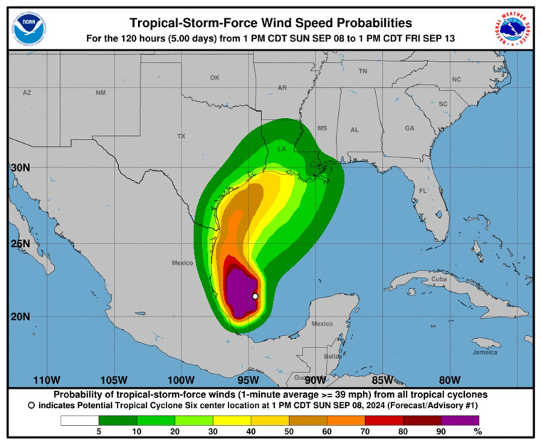 Potential Tropical Cyclone Six Wind Speed ProbabilitiesNOAA
"A slow northwestward to northward motion is expected over the next day or so, followed by a faster motion to the northeast beginning late Tuesday," according to the hurricane center. "On the forecast track, the disturbance is expected to move just offshore of the northern Gulf Coast of Mexico through Tuesday, and approach the Upper Texas and Louisiana coastline on Wednesday."
The hurricane center is expecting Potential Tropical Cyclone Six to bring heavy rain and the risk of flash flooding from the coast of northeastern Mexico to parts of coastal Texas and Louisiana through Thursday, with expected rainfall totals of 4-8 inches and up to 12 inches possible in some areas.
Minor coastal flooding is possible along Mexico's coast as well.
“While it is too soon to pinpoint the exact location and magnitude of impacts, the potential for life-threatening storm surge and damaging winds are increasing for portions of the Upper Texas and Louisiana coastlines beginning Tuesday night,” the hurricane center said.


 Bengali (BD) ·
  English (US) ·